Explore the Virunga Mountains
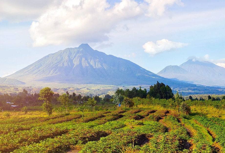
Explore the Virunga Mountains: The Virunga Mountains, a chain of volcanic mountains, form an active volcanic range in Central and East Africa distributed across the boundaries of Uganda, Rwanda, and the Democratic Republic of Congo. The term “Virunga” emanates from the Kinyarwanda term “Ibirunga,” which means “mountains.”
To many, it is also commonly known as the “Mufumbiro Mountains,” which entails 8 distinct volcanoes located along the western edge of the massive East African Rift Valley between regions of Lake Edward and Lake Kivu. This strategic location makes the Virunga Mountains geologically active and ecologically strategic.
This wide range comprises 8 volcanic mountains, with the tallest being Mount Karisimbi (4,507 meters), Mount Mikeno (4,437 meters), Mount Muhabura (4,127 meters), Mount Bisoke (3,711 meters), Mount Sabyinyo (3,671 meters), Mount Gahinga (3,474 meters), Mount Nyiragongo (3,470 meters), and Nyamuragira (3,058 meters).
Out of these, only two are believed to be geologically active and strategic. These include Mount Nyiragongo and Mount Nyamuragira, all located inside the Democratic Republic of Congo’s Virunga National Park, contributing over 40% of the volcanic eruptions in Africa’s history.
Mount Nyiragongo is one of the world’s most dangerous volcanoes, where its crater holds the world’s most active and largest lava lake. This volcano remains active with a persistent lava lake atop the crater. More still, Mount Nyamulagira, a shield volcano, is one of Africa’s most active volcanoes and last erupted in September 2024. Mount Nyamulagira has erupted about 40 times since 1885, while the remaining six volcanoes remain dormant.
Explore the Virunga Mountains: Out of all eight, Muhabura, Gahinga, and Sabinyo sit along the Uganda border, while Mount Karisimbi, Mount Mikeno, and Bisoke are shared by both Rwanda and the Democratic Republic of Congo. These volcanoes can easily be seen from the Ugandan side depending on one’s altitude, weather conditions, and angle. In Uganda, you can best see these volcanoes from Kanabe Gap along the Kabale-Kisoro Road, seeing all five of the region’s eight volcanoes.
Most of these volcanoes got their names from their topographical features and appearance; for example, Mount Sabinyo, which means “Old Man’s Teeth,” describes the volcano’s physical appearance, resembling an old man’s teeth.
The Virunga Volcanoes
Mount Muhabura
This is an extinct volcano that is commonly known as Mount Muhavura, located in the Mgahinga and Volcanoes National Parks in Uganda and Rwanda, respectively. It is the third-highest peak among the Virunga volcanoes, standing at 4,127 meters, with the steepest slopes. Travellers from a distance utilized Muhabura, which means “guide,” as a guide, being the highest in Mgahinga National Park.
Due to its steepness, it is the most challenging to climb. Not only amateurs but even experienced hikers normally find this hike difficult. At its peak, it has a crater lake with fresh, clear waters. Expect to see a variety of animal species on the trekking trail, including mountain gorillas, forest elephants, buffaloes, birds, and monkeys. It is possible to organize hikes in both Rwanda and Uganda.
Mount Karisimbi
With over 4507 meters, the tallest of the eight mountains and the eleventh highest in Africa is a dormant stratovolcano. This volcano is surrounded by Bisoke in the east, Mt. Mikeno in the north, and Nyiragongo on the border with the DRC in Rwanda. Locally it is called a white shell due to its snow-capped peak; this name, “amasimbi” in Kinyarwanda, subsequently gave rise to its current name.
Due to its challenging terrain and the renowned mountain gorillas, hiking this mountain is challenging but extremely rewarding. The journey to the top takes about two days, with the first resting place being at 3,700 meters. You can see a diverse animal species, like golden monkeys and several birds, while out on your safari. Feel free to pay your respect to Diane Fossey’s tomb due to her tremendous work that is credited with making gorilla trekking possible. Permits for hiking this volcano cost USD 400 per person.
Mount Nyamuragira
Explore the Virunga Mountains: This is the shortest of the eight mountains at 3,058 meters and is an active composite volcano that is found in the Democratic Republic of the Congo. Known as Africa’s most active volcano, it has erupted over 40 times since 1885, with the most recent eruption taking place on November 8, 2011. The Kinyarwanda term “Kuragira,” which means “herd cows,” is the source of the mountain’s name. Large volumes of sulfur dioxide have been emitted into the atmosphere by these periodic eruptions. A 500-meter-deep lava-dammed lake may be seen at the summit of the mountain after a hike up it.
Mount Sabyinyo
This is one of the extinct volcanoes that is only separated from Mount Muhabura, its next-door neighbor, by a 20-meter-diameter crater lake. Due to its jagged peak, which resembles worn-out teeth more like a gap between two teeth, Sabyinyo is known as the “Old Man’s Tooth.” The word “binyo” also means teeth in the Luganda dialect, which is widely spoken in Uganda. It may be found in Uganda’s Mgahinga National Park and serves as a boundary for Uganda, Rwanda, and the Democratic Republic of the Congo.
Since the terrain in the neighboring countries is so rugged, hiking is now limited to Uganda; however, preparations are in place to establish trails there as well. Due to its steep slopes, most of Uganda’s hiking trails are composed of handcrafted ladders. Along your trek, you will enjoy the scenic vegetation types ranging from dense woods to shrubs and bamboo plants. Animal species to see include buffaloes, monkeys, mountain gorillas, and others. Upon reaching the top, you can simultaneously see all three countries.
Mount Bisoke
Explore the Virunga Mountains: Mount Bisoke, also commonly known as “Visoke,” at 3,711 meters above sea level, is located in the Virunga Conservation Area and Volcanoes National Parks in the Democratic Republic of the Congo and Rwanda, respectively. Its greater part is located in Rwanda, and it features two crater lakes, including Lake Ngezi, which is located in Midway, and one at the top. Bisoke is one of the active volcanoes, whose last eruption was recorded in 1957.
Mount Gahinga
The phrase “a small mound of stones” is how the word “Gahinga” gets its name from the native Kinyarwanda/Rufumbira dialect. This dormant volcano is located in Kisoro District’s Mgahinga Gorilla National Park, near the border between Uganda and Rwanda.
The caldera on the mountain is thought to be 180 meters wide. It is easier to climb compared to Mount Sabyinyo and takes about 6 hours to hike. Along with the hike, there are numerous things to partake in, such as tracking gorillas and golden monkeys, bird watching, and cultural visits to nearby settlements.
Mount Nyiragongo
Nyiragongo, an active volcano with an active lava lake at the summit and one of Congo’s most renowned tourist destinations, is the only spot in Africa where visitors are permitted to have a close look at the lava lake.
It is the second-shortest mountain in the Virunga ranges, standing at 3,470 meters, making it the most popular volcano in Virunga National Park. Hiking doors were opened in 2014, and it takes around 4-6 hours to get to the summit, where you may spend the night by a lava lake.
Mount Mikeno
This is an extinct volcano with a height of 4437 meters, located in the Democratic Republic of the Congo’s Virunga National Park. It is the second-highest volcano in the wide Virunga ranges. Due to its rocky, steep slopes that restrict human activity, Mikeno, meaning “poor,” was attached to this volcano. Following its lush slopes and foliage, mountain gorilla hiking and treks are encouraged.
The best time to hike these mountains is during the dry season when the trails are less slippery compared to the wet season when these routes are muddy, slippery, and interrupted by the constant rains.